Blog search

Monday 29 January 2018

Postcard from United States Virgin Islands - USVI (Открытка с Виргинских островов США)

Postcard from USVI

stamps from Virgin Islands


Here is a new  paradise incoming postcard from United States Virgin Islands (USVI)!

       also called the American Virgin Islands), officially the Virgin Islands of the United States, is a group of islands in the Caribbean that is an insular area of the United States located 64 km east of Puerto Rico. The islands are geographically part of the Virgin Islands archipelago and are located in the Leeward Islands of the Lesser Antilles.
       The U.S. Virgin Islands consist of the main islands of Saint Croix, Saint John, and Saint Thomas, and many other surrounding minor islands. The total land area of the territory is 346.36 km2. The territory's capital is Charlotte Amalie on the island of Saint Thomas.
       In 2010 the population was 106,405, and mostly Afro-Caribbean. Tourism and related categories are the primary economic activity, employing a high percentage of the civilian non-farm labor force that totaled 42,752 persons in 2016.
       English is currently the dominant language and Spanish is spoken by about 17% of the population.
       This postcard was sent from St.John Island. At 50 km2 the smallest of the three main US Virgin Islands, Saint John is located about four miles east of Saint Thomas, the location of the territory's capital, Charlotte Amalie. It is also four miles southwest of Tortola, part of the British Virgin Islands. Its largest settlement is Cruz Bay with a population of 2,700. St. John's nickname is Love City.
 
Thank you very much for help dear Richard!
 

Postcard from Saba (Открытка из Саба)

Postcard from Saba

stamps from Saba


  This amazingly beautiful postcard was travelling to me during 5 month from Saba!
 
       is a Caribbean island which is the smallest special municipality (officially “public body”) of the Netherlands. It consists largely of the potentially active volcano Mount Scenery, at 887 metres the highest point of the entire Netherlands.
       Saba has a land area of 13 square kilometres. As of January 2013, the population was 1,991 inhabitants, with a population density of 150 inhabitants per square kilometre. Its towns and major settlements are The Bottom (the capital), Windwardside, Hell's Gate and St. Johns.
       Both English and Dutch are spoken on the island and taught in schools, and both languages are official. Despite the island's Dutch affiliation, English is the principal language spoken on the island and has been used in its school system since the 19th century. English can therefore be used in communications of and to the government. Saba English, a form of Virgin Islands Creole English, is the local vernacular.
 
I am very grateful to Saba Tourism Bureau!

Monday 15 January 2018

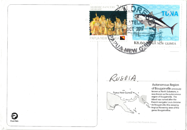
Postcard from Papua New Guinea (Открытка из Папуа-Новой Гвинеи)

Postcard from Papua New Guinea

Stamps from Papua New Guinea
  

Adorable incoming postcard from Papua New Guinea!

       officially the Independent State of Papua New Guinea, is an Oceanian country that occupies the eastern half of the island of New Guinea and its offshore islands in Melanesia, a region of the southwestern Pacific Ocean north of Australia. Its capital, located along its southeastern coast, is Port Moresby. The western half of New Guinea forms the Indonesian provinces of Papua and West Papua.
       At 462,840 km2 Papua New Guinea is the world's fifty-fourth largest country. Including all its islands, it lies between latitudes and 12°S, and longitudes 140° and 160°E. Papua New Guinea is surrounded by coral reefs which are under close watch, in the interests of preservation.
       The country is situated on the Pacific Ring of Fire, at the point of collision of several tectonic plates. There are a number of active volcanoes, and eruptions are frequent. Earthquakes are relatively common, sometimes accompanied by tsunamis
       Papua New Guinea is one of the most heterogeneous nations in the world. There are hundreds of ethnic groups indigenous to Papua New Guinea, the majority being from the group known as Papuans, whose ancestors arrived in the New Guinea region tens of thousands of years ago. The other indigenous peoples are Austronesians, their ancestors having arrived in the region less than four thousand years ago.
       There are also numerous people from other parts of the world now resident, including Chinese, Europeans, Australians, Indonesians, Filipinos, Polynesians, and Micronesians (the last four belonging to the Austronesian family). Around 40,000 expatriates, mostly from Australia and China, were living in Papua New Guinea in 1975.
 
Thank you so much for a help Pieter!
 

Postcard from Palestine (Открытка из Палестины)

Postcard from Palestine

stamps from Palestine

 
  One more rare incoming postcard from Palestine!
 
       officially the State of Palestine (Arabic: دولة فلسطين‎ ), is a de jure sovereign state in the Middle East claiming the West Bank (bordering Israel and Jordan) and Gaza Strip (bordering Israel and Egypt) with East Jerusalem as the designated capital although its administrative center is located in Ramallah. Most of the areas claimed by the State of Palestine have been occupied by Israel since 1967 in the consequence of the Six-Day War. The population is 4,550,368 as of 2014, ranked 123rd in the world.
       This postcard was sent from Bethlehem. It is a Palestinian city located in the central West Bank, Palestine, about 10 km south of Jerusalem. Its population is approximately 25,000 people. It is the capital of the Bethlehem Governorate. The economy is primarily tourist-driven.
 
I am very grateful to Yangyang!


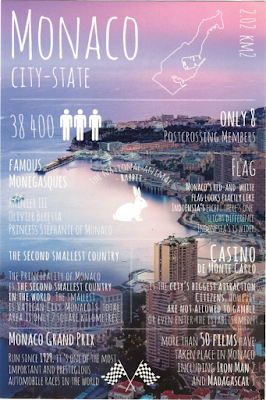
GF Monaco postcard

GF MonacoStamps from Monaco

New one incoming "Greetings from" Monaco!

Have only 8 postcrossing members!
Size: 2.02 sq.km
National animal: Rabbit
Population: 38400 people
City-state: Monaco
Famous monegasques: Rainier III, Olivier Beretta, Princess Stephanie of Monaco.

You can read more facts on this postcard.

Thank you so much dear Rosmarie!